Uttara Kannada at its best! Falls, Beaches and Nature.. All over

Uttara Kannada at its best! Falls, Beaches and Nature.. All over
Om beach, Sathodi Falls,Magodi Falls

Thanks for Visiting My Blog:

Sunday, February 17, 2008

Kumta Beach

Distance: 2km from Kumta Bus stand
Speciality: Sun Set view, Light trekking, Rocks around the beach
How to reach: Catch an auto from Kumta bus stand and ask the way to "Head Bander" beach.


I would say this is one of the unexplored place in Uttara Kannada. I have been living near to beach from almost 26 years from now. Every time I visit this beach, it gives me fresh idea and fresh life. Beach is around 2km from the Kumta bus stand. You get an auto to reach there. Preferred time is in the evening but you can go in early morning as well.

Just before reaching the beach, there is small bridge and you can see small boats on your left side. Just after the bridge you will see a small church on left. Few steps from here,beach stretch starts. On the left side it is beach and on right hand side it is fields where local people cultivate Onion during the summer season.Beach stretch is around half a KM. At the end of the Beach, you can climb up little bit to reach the top. You can take the bike/Auto till the top or you can walk as well.


You can stop at the start of the beach and can have a lovely walk along the beach. You can swim and have beach bath as well. Beach is not very deep and hence NOT to worry much while having beach bath. If you are interested in beach games, you can carry Frisbee, Foot ball, Valley ball and cricket kit. There is enough space to form your group and play. When you walk along the the beach, on the west side you see the rocks. You can climb up all the way and reach the top of the rock. There is two rocks which are leaning to each other. When I asked about this way back in 1993, I got the answer that it is symbol of Boy and girl loving each other. You can see the Sun set view from here.
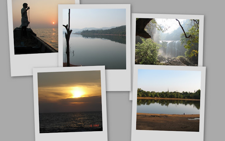
On the other end of the beach where the road ends, you can actually climb up again. Near to this there is a Government prawn factory. This is NOT functional now. When you climb up, you will see the old French monument. This was constructed by the French people before the Independence. During British time, Kumta beach was one of the important port where goods used to be exported. We can still see some traces of the Steps made by the British. This is a Top view where you can see entire beach view along with the fields around. Way back, there was a WELL in that area but it is now completely filled with the mud and it is NOT traceable any more now. This particular location is so AMAZING. You have to visit this place and spend at least 30 minutes. Relax your self, see the beach and the surrounding place. You will be in entire different world all together. Nice breeze, Sun playing with the sky. Sun set is so nice. See the photos.


Kumta beach is an inspiration for me all the time. Especially when I was studying my 2nd year PUC, I used to spend my free time lonely in the beach. Every time I visited this, I was energized more and more to study and experiment.

Whenever you visit this place, please make a note of taking some food and snacks along with your. There are NO shops available in the beach. This is because local people visit only during weekend and most of the people prefer NOT to buy eatables here. Some time you will get the ICE creams.

All together,this is place to spend the evening along with the family. Whenever you are in Kumta, make sure you spend one evening in the KUMTA BEACH.

Sunday, February 10, 2008

Choudi Gundi

Before you start reading,

I would like to thank my dear friend Venkatesh Channal who volunteered to spare his valuable time to describe one of the smallest places “Choudi Gundi”. This is small pond in mid of the forest with clean and refreshing water. Best time to visit is June to November. Not many people in UK or kumta know about this place. This place is very near to Kumta. From Kumta bus stand reach the “Muroor cross” which is around 2 km from bus stand. After the “Muroor cross”, walk towards “Siddana Bhavi”. From here ask any one for the local people about how to go to “Choudi Gundi”.

Here is how my dear friend Venkatesh Channal shares his experience

I would like to share one of my experiences as a boy growing up in the residential school of Jawahar Navodaya Vidyalaya Kumta the place where JNV used to be before it got shifted to Panchavati.

Swimming at Choudi Gundi

Being part of a residential school known for its discipline didn’t stop the boys from enjoying to swim in the natural waters of Choudi Gundi. As the expedition was not authorized and being caught in the act would lead to severe punishments it was one of those things that needed very good planning and execution.

The Choudi gundi happened to be a pond amidst the nature for which the district of Uttara Kannada is well known for. Reaching the pond required a trek across a couple of hills and a journey of around 3 KM each way from our hostel. The time best suited for this swimming experience was our study period which would commence from 3 pm till 4:45 pm. Soon after completing our lunch which most of us would do in a hurry so as to not lose any of our swimming time J, it was time for us to sneak out through the back doors after having made suitable arrangements to cover our bases incase one of the duty masters came around taking attendance for each of the students. These arrangements would be usually studying in the classrooms or in some other room as students were allowed to study in either of the places.

As the swimming could host around 15-20 people at a time it was usually the matter of first come first serve so reaching the place early was paramount. The locals had so got used to seeing boys from Navodaya going to the pond at around 2:30 to 5 every day that they would reschedule their timings accordingly. So once we had our lunch it was time to get the necessary clothing and start to run through the hill to reach the place. Though we used to have cross country trek regularly I must acknowledge that this particular running exercise through and fro to the swimming pool gave us as much stamina as any of the regular exercise drills. One of the difficult passages was getting across the top of the hill not as much due to traveling difficulties as it was due to leave us vulnerable to become visible from the school premises which was to rest assured that a grand punishment would be in the offering once we were backJ. But us boys being boys we usually took it as part of the challenge. After making across the hill it was comparatively easy sailing with it requiring just crossing the slopes and a rough path of the forest and then the getting to the actual pond by having to pass through the slippery stones along the way of the water bed. The beauty of the place was certainly worth more than all the effort and that is why it was such an attraction for all of us. No season was a barrier as if there was water to swim we would be there come rain or sun.

The water was flowing so it avoided the risk of being stagnant and dangerous in terms of us getting infected by germs. Being in that place was a way to be totally separate in our own little world was all we did was have fun and enjoy. No study, no routines, no worries. It was just plain old fun. We had rocks inclined at various heights giving us an opportunity to be adventurous to take a dive from heights. The greenery, the calm, the serenity of the place is something that I still behold dearly.

The place was called Choudi gundi as it was widely believed that it was place where Choudi would roam around in the night. Folks from UK would be well accustomed to hearing about Choudi I guess and for those who don’t know Choudi is sort of village deity who is known for playing pranks. There used to be bets among boys for going to Choudi gundi during the new moon night and I remember once where a couple of my friends took the challenge and went there only for their battery to go down on the way back. How they made their way back is still a mystery for me as traveling in the forest and the hill in total darkness is not an ordinary skill and it does require lot of courage.

Now coming back to my experience, after spending around 1.5 to 2 hour swimming and having fun it was time for us to head back. If we found any fruits along the way in the forest it was a bonus else we had to go hungry and exhausted to our (official) play time. And being as exhausted as we used to be still we had to reach our dormitories by 5:15 as that is when the PT period would commence and attendance would be taken compulsorily and if were late, the less said about it the better.

This was an experience that I wanted to share with all folks from our group hope you got a glimpse of it and yeah happy sharingJ.

Saturday, February 9, 2008

Places in Uttara Kannada

Below are the places in uttara kannada. You will have to wait some more time to get more information about each place.

Near KARWAR
Tagore Beach
Devbag
Sadashivgad
Tilmati Beach
Kurumgad Island
Guddalli Peakn
Katyayani Temple
Kadra dam
Ulavi
Anshi

Near Ankola:
Belekeri Beach

Near Kumta:


Choudi Gundi

Gokarn
Om Beach
Yana
Alvekodi Beach
Dhareshwar

Near Honnavar:
St. Xavier Church, Chandavar
Murdeshwar
Apsara Konda
Idagunji
Basavaraj Durga Island
Karikannamma Temple
Higund
Gerusoppa
Gerusoppa Valley
Haduvalli

Near Haliyal:
Dandeli
Kavala Caves
Sintheri Rocks
Castle Rock
Ambikanagar
Tibetian Settlement

Near SIRSI
Marikamba Temple
Banavasi
Sonda
Sahasra Linga
Shivganga Falls
Kavadi Kere
Jenu Kallu Gudda
Magod Falls
Sathodi Falls
Unchalli Falls
Burude Jog
Jog Falls
Attiveri Bird Sanctuary

Taluks in Uttara Kannada

There are total of 11 Taluks in Uttara Kannada. Out of these First five are in costal area. Karwar is district head and has a DC office in it. Below are the taluks in Uttara Kannada

Karwar
Ankola
Kumta
Honnavar
Bhatkal
Yellpaur
Sirsi
Siddapur
Mundgod
Haliyal
Joida

Uttara Kannada Geographical location

Uttara Kannada is a district in the southern Indian state of Karnataka. It is sometimes called North Canara, or North Kanara. It is bounded on the northwest by the state of Goa, on the north by Belgaum district, on the northeast by Dharwad District, on the east by Haveri District, on the southeast by Shimoga District, on the south by Udupi District, and on the west by the Arabian Sea.

The main geographic feature of the district is the Western Ghats or Sahyadri range, which runs from north to south through the district. Between the Sahyadris and the sea is a narrow coastal strip, known as the Payanghat, which varies from 8 to 24 km in width. Behind the coastal plain are flat-topped hills from 60 to 100 meters in height, and behind the hills are the ridges and peaks of the Sahyadris. East of the Sahyadris is the Balaghat upland, part of the vast Deccan plateau.

Moisture-bearing winds come from the west, and yearly rainfall averages 3000 mm on the coast, and as high as 5000 mm on the west-facing slopes of the Sahyadris. East of the crest is the rain shadow of the Sahyadris, which receive as little as 1000 mm annually. Much of the rain falls in the June-September monsoon.
Four principal rivers drain westwards from the crest of the Sahyadris to the sea; from north to south they are the Kali, Gungawali, Aghanashini and Sharavati. These rivers form numerous waterfalls, the most famous of which is Jog falls, on upper reaches of the Sharavati in neighboring Shimoga district. Other famous waterfalls include Unchalli Falls, where the river Aghanashini drops 116 meters, Magod falls, where the Bedti river plunges 180 meters in two leaps, Shivganga falls, where the river Souda drops 74 meters, and Lalguli and Mailmane falls on the river Kali. In the lowlands, these rivers form wide estuaries, extending several kilometers inland from the coast.